Managing an island territory means managing interconnected systems. Tourism affects infrastructure, natural resources and public services; water availability influences environmental resilience; and coastal conditions shape both visitor experience and emergency response. The challenge is therefore not simply to collect more data, but to connect information held by different organizations and transform it into knowledge that supports real decisions.
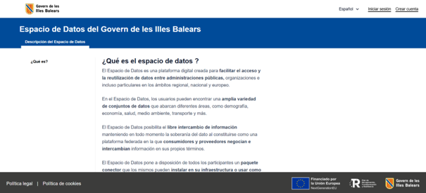
This is the ambition behind the digital twin and data space infrastructure to support territorial management, a project led by the Directorate General for Innovation and Digital Transformation of the Government of the Balearic Islands and implemented by NTT DATA , launched as the Balearic Islands Data Space (Espai de Dades del Govern de les Illes Balears) was not conceived as an add-on. It is a core of the solution. Its components include a data catalog, a Participant registry, a vocabulary library, observability services and Connectors that support interactions between Participants and the application of access and usage policies, components developed by NTT DATA. This makes it possible for bodies responsible for water resources, emergencies, land planning, statistics, cartography and tourism to share data that was previously scattered across administrations and private sources, while each data provider keeps control over how its data is used.
The data space is open to companies and other organizations in the archipelago, and an agreement between the Government and the Federation of Local Entities of the Balearic Islands (FELIB) lays the groundwork for town councils to join. Its governance has also been recognized externally: it is included in the Trust List of the Spanish Data Spaces Reference Center (CRED), whose criteria are based on the UNE 0087:2025 specification, and the Balearic Islands are the only Spanish region with a data space on that list.
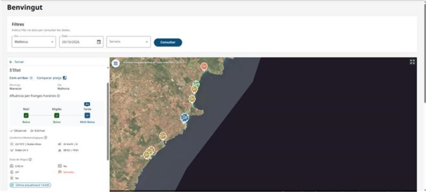
On top of this foundation, the knowledge layer integrates and processes information, while advanced analytics transform data into actionable insights. The tourism use case shows this clearly. NTT DATA developed predictive capabilities to anticipate beach occupancy, combining different sources of information to provide a forward-looking view of how pressure on coastal areas may evolve.
Beach occupancy models combine historical occupancy data with real-time updates provided by lifeguards during the periods when lifeguard services are active, together with calendars and holidays, environmental conditions, and meteorological and metocean data. As occupancy data relies on lifeguard reporting, real-time occupancy information is not available outside the lifeguard service season. The models adapt predictions to different islands, seasons and groups of beaches. During the active season, these forecasts are made available through the public web platform (platges.illesbalears.travel), which provides current occupancy information and a seven-day forecast for each covered beach. The objective is practical: anticipating congestion can support resource optimization, environmental management, visitor experience and strategies to reduce pressure on the most saturated locations..
As of October 2026, 84 beaches provide real-time occupancy data and forecasts: 37 in Ibiza, 26 in Menorca, 16 in Mallorca and 5 in Formentera. During the periods when lifeguard services are active, occupancy information is updated several times a day. The system has been designed with a flexible architecture capable of accommodating additional data sources as needs evolve.
Together, these capabilities show how a digital twin can move beyond visualizing what is happening and begin to anticipate what may happen next. But tourism was only one part of the project. The same infrastructure supports additional use cases in water management and coastal emergencies. In water management, the digital twin brings together water-resource information with other territorial data available through the data space, providing an integrated view to support resource planning, water efficiency and resilience, as well as the anticipation of scenarios such as drought or contamination events. In coastal emergencies and medical assistance, the digital twin brings together relevant territorial information to support coordination between services and better-informed responses to rescues, maritime accidents and extreme weather events.
This multidomain approach is central to the project’s value. Instead of isolated solutions for each problem, the Balearic Islands now have a reusable territorial data infrastructure where participants, datasets and use cases can be incorporated under a common governance framework. The infrastructure also provides a foundation for extending the digital twin to additional use cases that are still to be defined. Potential future areas could include mobility, forest management or other territorial challenges, depending on the evolving priorities and needs of the Balearic Islands. New use cases can build on both the existing data space and digital twin platform, reusing common governance, data-sharing, integration and visualization capabilities rather than requiring a new ecosystem and technological foundation to be created from scratch.
The Balearic Islands project demonstrates the complementary role of data spaces and digital twins. Data spaces provide the trust, sovereignty, governance and interoperability required to collaborate around data. Digital twins provide the context in which those data can become understandable, predictive and actionable. By combining both, NTT DATA has translated data-sharing principles into a concrete environment that already delivers forecasts to citizens and supports better-informed territorial decisions. This approach also provides a scalable foundation for future territorial services, because new data providers and use cases can be integrated without rebuilding the ecosystem from scratch. For public administrations, that means moving from isolated data projects toward a reusable capability for evidence-based policy and operational planning.
Project at a glance
Promoter: Directorate General for Innovation and Digital Transformation, Government of the Balearic Islands
Technology partner: NTT DATA
Budget: EUR 4.6 million, 75% NextGenerationEU funding
Use cases: tourism, water lifecycle, coastal emergencies and medical assistance
Recognition: included in the CRED Trust List of data spaces
Status: data space available; Tourism Digital Twin (beach forecasting) in test phase since July 2026
Public platform: platges.illesbalears.travel
Coverage: 84 beaches with real-time data and forecasts (October 2026)